About Alresford
'The ford over the river where the alder trees grow.'
The Millennium Trail and The Alre Valley Trail
The Millennium Trail links footpaths around the town with illustrated boards that give information on the history of Alresford, its inhabitants, wildlife and countryside setting. The walk is about one mile and is suitable for wheelchair users and pushchairs. The Arle Valley Trail branches off the Millennium Trail and then rejoins it about one and a half miles later. It lets you see at closer hand some of the lovely surrounding countryside. Wheelchair access is difficult after the Eel House.
The information is contained in a separate leaflet, Alresford Millennium Trail, which is available from the Station Information Office, the Library and many of the shops in the town as well as being reproduced below.

The Millennium Trail
Look out for the display boards round the trail with details of what to see and local history.
The Station Yard
The Millennium Trail begins in the Station Yard where parking is available. The railway came to Alresford in 1865 and greatly assisted the developing watercress industry as it allowed access to markets in London and beyond. Watercress remains a significant local industry and is celebrated at the annual Watercress Festival on the third Sunday in May. The steam trains running on the Watercress Line are now a major tourist attraction. The restored building to the right of the platform is the Goods Shed that has a visitor information point and railway shop.
Having collected a leaflet from the Station Information Office, you will find the first board to the right of the main entrance. Leave Station Yard and walk down Station Road to the diagonal path, opposite the toilets, leading into the churchyard on your right. Turn left into the churchyard towards the church tower and west door.
Churchyard
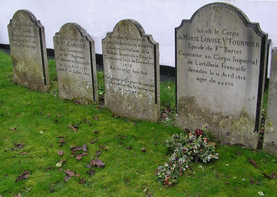 The tower is the oldest part of Alresford's parish church of St John the Baptist. Above the door is a small Saxon rood, a sculpture of Christ. Opposite are the graves of four French Napoleonic prisoners of war, and one of their wives.
Continue on the path towards the junction of East, West and Broad Streets.
East Street
Although the Millennium Trail does not take you along East Street, it is worth a visit to see its beautiful colour-washed Georgian architecture. At the end of the street is The Old Sun Inn once the home of John Arlott, the journalist and broadcaster, for some 20 years.
Ahead of you is:
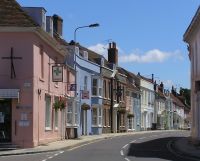
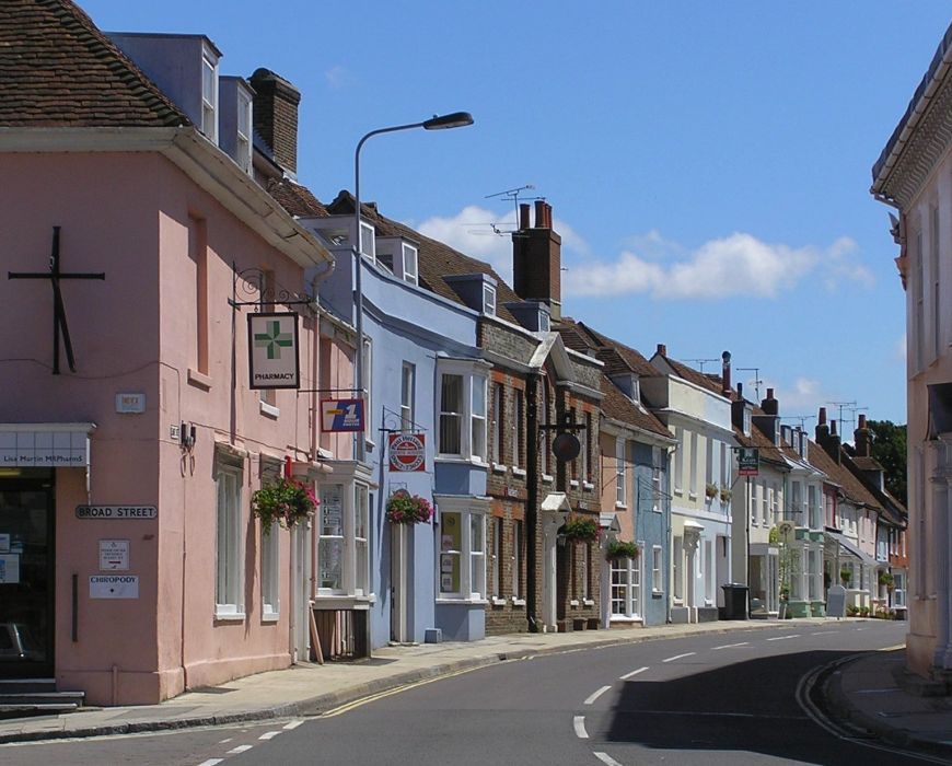
Broad Street
 One of Hampshire's finest street scenes, essentially Georgian, it was laid out at the beginning of the 13th century by Bishop de Lucy,
who built a town called Novum Forum, Latin for 'New Market'. Alresford is mentioned in the Domesday Book and the new town was for many
centuries thereafter a prosperous wool centre and a market hall probably stood in the centre of the road at the top Broad Street. Its open
ground floor would have been used by traders, while the upper floor may have held general meetings or specialist markets. There have been
markets and fairs in Broad Street for 800 years and as many as 32,000 sheep were penned at one time at the annual fairs held in the 19th
century. Broad Street still hosts a market on Thursday and specialist markets are held during thw course of the year including the internationally acclaimed Watercress Festival on the third Sunday in May.
One of Hampshire's finest street scenes, essentially Georgian, it was laid out at the beginning of the 13th century by Bishop de Lucy,
who built a town called Novum Forum, Latin for 'New Market'. Alresford is mentioned in the Domesday Book and the new town was for many
centuries thereafter a prosperous wool centre and a market hall probably stood in the centre of the road at the top Broad Street. Its open
ground floor would have been used by traders, while the upper floor may have held general meetings or specialist markets. There have been
markets and fairs in Broad Street for 800 years and as many as 32,000 sheep were penned at one time at the annual fairs held in the 19th
century. Broad Street still hosts a market on Thursday and specialist markets are held during thw course of the year including the internationally acclaimed Watercress Festival on the third Sunday in May.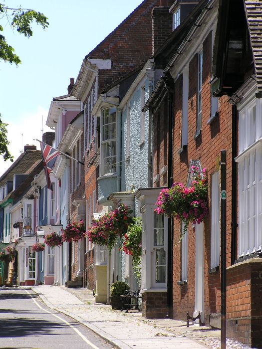
Most of the houses have been destroyed by fires over the centuries. After the last major fire in 1689 they were rebuilt in elegant Georgian brickwork over the original Norman cellars. Although No. 43 looks brick-built, it is a timber-framed building faced with less weighty, mathematical tiles. Note the false window, perhaps to avoid window tax, over the front door! No.46 opposite was the headquarters of the 47th Infantry Regiment, US Army from 1943 to D-Day 1944.
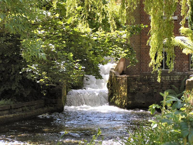
At the bottom of Broad Street, is the Old Fire Station, built in 1881, which now houses the town's Museum. A small diversion past the fire station, towards The Globe pub, and then down the footpath immediately to the right takes you to Old Alresford Pond, and the commemorative tablet to Capt. James Cogswell, USAF. The pond came into being at the end of the 12th century when Bishop de Lucy, built the Great Weir and created not only a fishpond but a head of water to drive the many mills to be built down stream. From this area the Bishop once boarded his boat to cross the pond to his palace at Bishop's Sutton. (Retrace your steps)
Bear left at the bottom of Broad Street
Mill Hill
 The houses in Mill Hill have a chequered history. Near the top on the left is Old Timbers; the central part dates from the 14th
century, together with its neighbour they are possibly Alresford's oldest houses. Note the old Insurance Company firemark on the front
of Old Timbers. Further down on the left were workhouse tenements and the Overseer, William Wickham, lived next door at Wickham House.
At the bottom, on your right, is the Town Mill, which was rebuilt in the 1890s and fitted with modern turbines instead of paddles.
(Retrace you steps)
The houses in Mill Hill have a chequered history. Near the top on the left is Old Timbers; the central part dates from the 14th
century, together with its neighbour they are possibly Alresford's oldest houses. Note the old Insurance Company firemark on the front
of Old Timbers. Further down on the left were workhouse tenements and the Overseer, William Wickham, lived next door at Wickham House.
At the bottom, on your right, is the Town Mill, which was rebuilt in the 1890s and fitted with modern turbines instead of paddles.
(Retrace you steps)
Turn into Ladywell Lane, opposite the trail board on your right.
Ladywell Lane
 As you walk down the lane, you will see the springs that flow all year round, and see if you can spot the wild watercress. At the
end of the lane is the fine, red brick, early 18th century Arle House, once the home of a master tanner
As you walk down the lane, you will see the springs that flow all year round, and see if you can spot the wild watercress. At the
end of the lane is the fine, red brick, early 18th century Arle House, once the home of a master tanner
Take the footpath that leads off the right side of the lane.
To the right of this stretch of footpath is an area now reserved for wildlife. Through the trees to the right you will just glimpse Weir House, once the home of a local benefactor, Sir Francis Lindley. As you reach the end of this stretch of the footpath, on your left is the Memorial Garden, given to the town by Sir Francis in 1951. This area is still used for family picnics and the site of the original open-air swimming pool can be seen edged in brick.
The River Alre
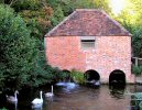
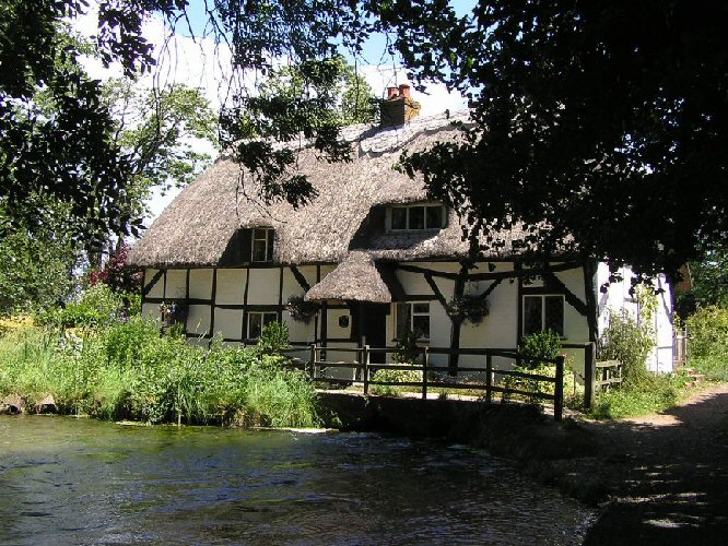 Just past the garden the footpath runs alongside the Alre for some 200 metres. Looking ahead you will see the thatched, timber framed
Fulling Mill, which spans the river. Built in the 13th century it used water driven hammers to work raw cloth into a useable
material.
Just past the garden the footpath runs alongside the Alre for some 200 metres. Looking ahead you will see the thatched, timber framed
Fulling Mill, which spans the river. Built in the 13th century it used water driven hammers to work raw cloth into a useable
material.
 As you pass the mill, the bed of the river joins Pinglestone Road - an ancient highway which has run along this riverbed for centuries.
This is probably the best stretch of the river to see the large variety of local plants and wildlife. Birds range from the ever-present
ducks to the elusive Kingfisher.
As you pass the mill, the bed of the river joins Pinglestone Road - an ancient highway which has run along this riverbed for centuries.
This is probably the best stretch of the river to see the large variety of local plants and wildlife. Birds range from the ever-present
ducks to the elusive Kingfisher.
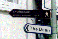
At the end of the path you will reach the bottom of The Dean. At this point you can take a short cut back to town by walking up The Dean. To continue on the Millennium or Arle Valley Trails, turn right and follow the river along the footpath.
 Bordering this part of the river are some fine horse chestnut trees and also some alders from which Alresford seems to take its name.
The Saxon name was 'a ford where the alder trees grow', and the River Alre takes its name from this. Look out for the grave of Hambone
Junior, canine friend of American soldiers billeted near Alresford prior to D-Day in 1944.
Bordering this part of the river are some fine horse chestnut trees and also some alders from which Alresford seems to take its name.
The Saxon name was 'a ford where the alder trees grow', and the River Alre takes its name from this. Look out for the grave of Hambone
Junior, canine friend of American soldiers billeted near Alresford prior to D-Day in 1944.
150 metres from The Dean you will reach a kissing gate. This is where the 1.6 mile Arle Valley Trail leaves the Millennium Trail to continue down the valley. (Turn over for information on that Trail) To continue on the Millennium Trail pass through the gate and cross Arlebury Park Recreation Ground towards the building at the top of the hill.To follow the directions for the Millennium Trail click here
The Alre Valley Trail
 Within a three-mile radius of St John's, the parish church, there are some 60 miles of paths and tracks. Many of these are hundreds of years
old. The Arle Valley Trail gives you an opportunity to see at closer hand some of the lovely countryside that surrounds Alresford. Also, for
the more adventurous, the trail leads to two opportunities for longer walks if you so wish.
Within a three-mile radius of St John's, the parish church, there are some 60 miles of paths and tracks. Many of these are hundreds of years
old. The Arle Valley Trail gives you an opportunity to see at closer hand some of the lovely countryside that surrounds Alresford. Also, for
the more adventurous, the trail leads to two opportunities for longer walks if you so wish.
As you walk along the river bank you will cross a number of small streams flowing under the footpath. They are now used to take water to the adjacent fish farm, but in earlier times one of them, called Ram Stream, led water to an intake chamber from which a ram pump kept Arlebury House supplied.
At the end of this stretch you will reach the Eel House.
Use the footbridge to cross over the river and continue down the other bank.
The Eel House
 Built in the 1820s and recently restored, it is where eels were trapped on moonless autumn nights, as they undertook their once in a lifetime
migration to breed. The Eel House sluices, then and now, also control the water levels in the river and the surrounding fish farms.
Built in the 1820s and recently restored, it is where eels were trapped on moonless autumn nights, as they undertook their once in a lifetime
migration to breed. The Eel House sluices, then and now, also control the water levels in the river and the surrounding fish farms.
The Eel House sitting astride the river can be viewed externally at all times but it is also open to the public on certain public holidays and other occassions. For details see www.towntrust.org.uk or town notice boards.
You have now crossed the parish boundary and are in Old Alresford. As you climb up the slope you reach an area called New England; quite why we have been unable to discover - perhaps there is some unknown link to America. The two cottages on your left are know as New England Cottages, built in 1700. Records show that in 1891 they were occupied by agricultural labourers from the Arlebury Estate, a family of five in one and an elderly couple with a lodger in the other.
Please keep to the footpath at this point as it skirts a private parking area.As you walk beyond the cottages you will see a footpath in the field on your right. If you want a bird's-eye view of Alresford and the upper Arle Valley climb this path, cross the road and continue 100 metres up the next field before you look back over the town. If you continue on this route you will join a series of paths and tracks that allow extensive walks in the countryside to the north.
For those returning to the Arle Valley Trail, turn right and continue along the bottom edge of the field.Along this stretch there are a number of opportunities to look across the extensive lakes and ponds that form the Arle Valley fishery. Many are of recent construction, hut the oldest date back to the 18th century when they were created for the pleasure of the owners of Arlebury House.
You have now reached Drove Lane. Please take extra care on the first section where, as you turn left, visibility is limited.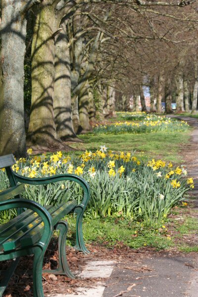 About 200 metres down Drove Lane you re-cross the river and on your right are the water meadows referred to on the board at the beginning of the trail. The river here was used in the Second World War
by tanks practicing river crossings, hardly a challenge compared to the rivers of Europe.
About 200 metres down Drove Lane you re-cross the river and on your right are the water meadows referred to on the board at the beginning of the trail. The river here was used in the Second World War
by tanks practicing river crossings, hardly a challenge compared to the rivers of Europe.
The remainder of the trail is along the footpath on The Avenue, probably one of the most pleasant approaches to any town in Hampshire or indeed England. originally a recreation area for the town owned by the Bishop of Winchester, for the last century it has been looked after by the Town Trustees. In spring time the many beds of daffodils planted by the Rotary Club line the walk and in summer the two lines of mature limes give pleasant shade. part way along you will pass Turnpike House a fine red-brick hexagonal building that was originally a tollhouse.
Rejoin the Millennium Trail at the gates of Arlebury Park Recreation Ground.Arlebury Park
You are now in Arlebury Park Recreation ground. As you climb the slope past the skateboard park and children's play areas you will see, on your right, Arlebury Park House. Built in the 18th Century and once the 'big house' of New Alresford today it is private apartments. Looking back to the north there is a splendid view across Fobdown and Old Alresford parish church can be glimpsed through the trees to your right.
When you reach the main gates to the recreation ground, turn left. Do not miss the information board just to the left of the gates. Here the Arle Valley Trail, which runs along The Avenue, rejoins the Millennium Trail. Please continue for information on the remainder of the Millennium Trail.
The Dean junction with Pound Hill
 As you turn left you will walk under the last of a splendid avenue of lime
trees planted in the 19th century. At the end of The Avenue you will walk down Pound Hill, the site of a 'pound' for stray animals. It was also the location of a Hurdle House where hurdles for
the sheep markets were stored. The house below the Running Horse, once a pub but now a private house, is a good example of an early 18th century house.
As you turn left you will walk under the last of a splendid avenue of lime
trees planted in the 19th century. At the end of The Avenue you will walk down Pound Hill, the site of a 'pound' for stray animals. It was also the location of a Hurdle House where hurdles for
the sheep markets were stored. The house below the Running Horse, once a pub but now a private house, is a good example of an early 18th century house.
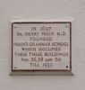 As you cross the top of The Dean, immediately on your left is the original Perins School building. In 1697 Dr Henry Perin founded Perin's Grammar School located here until 1932 when it moved to its present site, that you have just passed on the opposite side of the road.
In the remaining walk up West Street you will notice, as in Broad Street, a number of small lanes which were associated with Alresford's brewing trade. At one time the town is reputed to have had 32 pubs; two old coaching inns, The Bell and The Swan remain.
 East Street
The walk ends as it began by passing through the churchyard. Perhaps you might also spare a moment to look into East Street or Ram Alley, as it used to be called, here you will find more shops and Georgian houses, before having a cup of tea or a bite to eat before returning to your car or the station?
Adventures on the River
 Throughout the Spring and Summer of 2010, Binky Bear was photographed along the Millennium Trail in Alresford as he had his 'big adventure' and every step was recorded. His story has been written in rhyme and a book created that contains a map showing the route young Binky takes, so you can follow in his footsteps. Binky is a very furry bear, about 30cm tall and he wears a dark green velvet waistcoat with three shiny gold buttons and a spotted handkerchief tied around his neck. You will recognise him immediately if you see him!
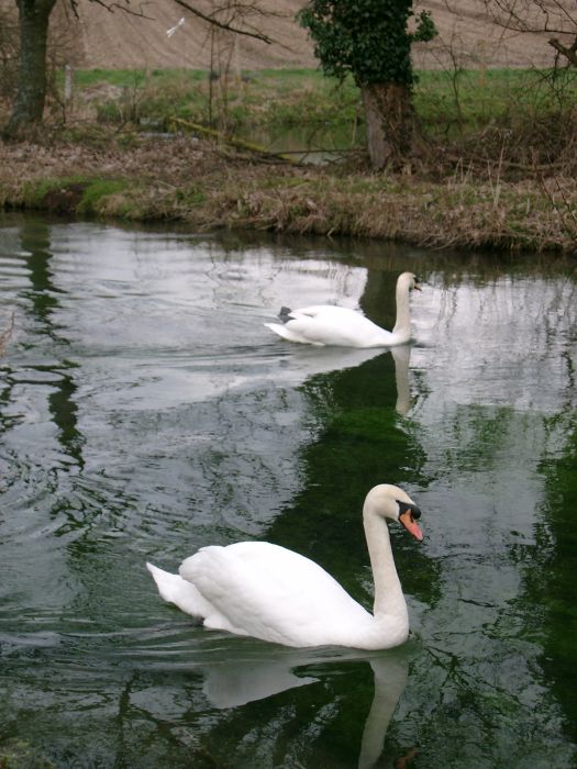
Binky Bear is the creation of Moira Blackwell and Liz Nankivell who both live and work close to Alresford. Binky's Big Adventure is a stunning picture book that will appeal to children and bear enthusiasts of all ages. It is based on a section of the Millennium Trail which the authors love and have walked many times with their own families. The photograph shown here is from the book and was taken early, one September morning in 2010. It shows one of the most spectacular sights on the Alre river, a family of beautiful swans and cygnets.